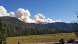
The McClusky fire, currently estimated to be 974 acres, has been actively burning as temperatures have been above normal and winds ahead of the anticipated cold front move through the area today. Smoke from the fire is visible from locations on or adjacent to National Forest System lands, nearby communities, and I-90. Fire managers are monitoring weather and changes in fire activity throughout the day. Currently the fire spread is to the north, south, east, northeast and southeast. Standing snags and those hung-up or suspended in adjacent snags pose an excessive safety risk to firefighters.
Fire crews are available to implement suppression actions from indirect line utilizing old road, trail systems, and natural barriers, providing a location where firefighters can safely engage the fire with a high probability of success.
The fire is currently reported at 51% Complete. Containment is a percentage that represents fireline built directly on the fire’s perimeter. Containment is considered in the percentage of completion. Currently the fire is 0% contained, but 51% of indirect suppression actions have been completed.
The lightning caused McClusky fire, located three miles northeast of Delmoe Lake and 13 miles northwest of Whitehall was reported on August 16. A total of 72 personnel are assigned to the fire, including, two Type 1 Hotshot crews, two engines, and miscellaneous overhead and support.
Fire Weather Forecast: Warm and dry conditions will occur through Thursday. A dry cool front will pass through the region Wednesday afternoon resulting in gusty westerly winds and low relative humidity’s, especially in the Beaverhead-Deerlodge NF. Winds will diminish after sunset. Expect a significant pattern change with widespread wetting rains Friday and again Sunday and Monday.
Closure: This closure is for public safety due to wildland fire suppression operations associated with the McClusky fire. Beginning in T2N, R5W, section 28, Forest Development Road (FDR) 173 – (Whitetail Road), continuing northward for approximately 3 miles to the junction of trail 7093 in T3N, R5W, section 15.
Trail 7093, from its junction with Forest Development Road 173 in Section 15 T3N, R5W for approximately 5.7 miles to the junction of Forest Development Road (FDR) 8695-Halfway Creek Road in, T4N, R5W section 31.
Fire restrictions are not in effect on the Beaverhead-Deerlodge National Forest, however, visitors are reminded to be careful while recreating in the forest. Be sure to extinguish campfires completely. Keep all motorized vehicles on roads and trails. Keep informed of other area restrictions by going online to https://firerestrictions.us.
For more fire information visit https://inciweb.nwcg.gov/incident/6524/.%20.