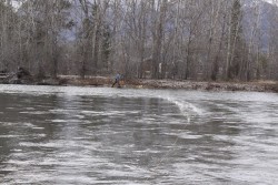
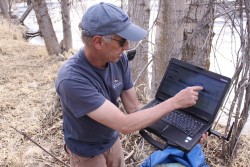
Dean Snyder a Hydrogeologist and others from the Montana Bureau of Mines and Geology were on the Bitterroot River near the woodside bridge in Corvallis last week measuring river flow and taking data samples.
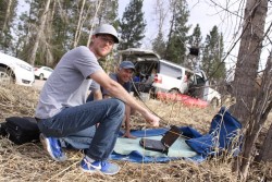
The measuring equipment is placed on a floating raft and sends signals to the bottom of the river periodically measuring depth, water flow and removing water samples to create a data base for assessing water quality and impact of long term water usage.
The Program is funded by money allocated during a previous Montana State Legislative session and will occur over several years.
Dean Explained that the data may be used for a variety of things including future increases in water usage in the Bitterroot Valley.
Water usage needs and local impact must be assessed as close to the usage site as possible to ensure that the appropriate measures are taken to ensure longevity of our water resources.
Examples include future sub-developments, business expansions and changes in Ranchers needs.
For more information check out www.mbmg.mtech.edu