
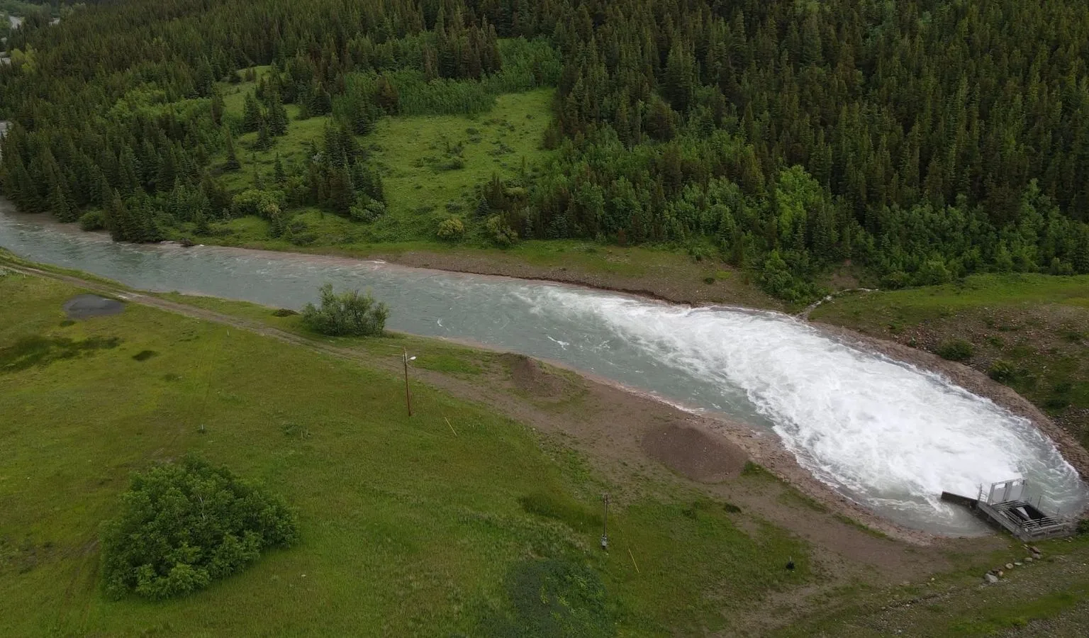
Mother Nature just threw a massive curveball at the Milk River watershed, but the team at Lake Sherburne was already holding the bat. Following a heavy five-inch deluge, reservoir operators have cracked the gates to maximum capacity. It’s a fast-moving, impressive sight, but it’s completely under control.
Keeping a reservoir stable when it’s being pounded by historic inflows isn’t luck; it’s a round-the-clock game of precision math and constant vigilance. Right now, inflows and outflows are perfectly matched, keeping the lake right where we want it.
Here’s the latest from The Milk River Project:
High flows continue to be released from Lake Sherburne near Babb, Montana. With nearly 5 inches of precipitation falling across the watershed, inflows into the reservoir have increased significantly. Releases have been opened to their maximum capacity, and at this time reservoir operators are successfully keeping the lake below the spillway.
Crews have been on site around the clock, monitoring conditions and ensuring everything continues to operate safely and smoothly. While it is an impressive amount of water moving through the system, operators are currently able to match reservoir outflows with incoming inflows, helping maintain stable conditions.
A special thank you goes to Tom and Clayton for their dedication and countless hours monitoring conditions around the clock. Their vigilance, expertise, and commitment during this high-water event have been instrumental in keeping the system operating safely. We are incredibly grateful for their hard work and the long hours they continue to put in to protect the Milk River Project and the surrounding communities.


Photos via The Milk River Project
Why Lake Sherburne and the Milk River Project Matter
Lake Sherburne sits on the eastern edge of Glacier National Park near Babb, Montana, cradled in the Many Glacier Valley. It’s a stunning piece of infrastructure tucked into one of the most dramatic landscapes in the Lower 48 — but it’s far more than a scenic reservoir. Lake Sherburne is the backbone of the Milk River Project, a federal water storage and delivery system that has served the Hi-Line region of northern Montana for well over a century.
The Milk River itself is the lifeblood of a vast stretch of north-central Montana. It flows eastward across the Hi-Line, eventually crossing into Canada before looping back into Montana and ultimately joining the Missouri River. The river and its tributaries support agriculture, municipal water supplies, wildlife habitat, and recreational opportunities across one of the most arid and agriculturally dependent regions in the state. Without the storage and controlled releases provided by Lake Sherburne and the Milk River Project, farming communities from the Rocky Mountain Front all the way to the North Dakota border would be working on a much narrower margin.
For hunters and anglers, the Milk River corridor is also genuinely productive country. The river and its associated wetlands provide habitat for a wide range of species — from white-tailed deer and pheasants in the river bottoms to migratory waterfowl that pile into Hi-Line potholes and reservoirs every fall. Healthy, well-managed water flow through this system has direct downstream consequences for all of it.
What Five Inches of Rain Actually Means for a Watershed
To put this rainfall event in perspective: five inches of precipitation falling across an entire watershed in a short period is a significant hydrological event by any measure, particularly in semi-arid northern Montana. The Milk River watershed drains a massive area, pulling water from the Rocky Mountain Front and the rolling plains to the east. When that much moisture falls that fast, every creek, coulee, and drainage funnel becomes a firehose pointed directly at Lake Sherburne.
Snowmelt earlier in the season can already have reservoirs running near capacity heading into late June, which means any sudden influx of runoff demands immediate, expert management. A spillway event — water going over the top of the dam uncontrolled — is something operators work hard to avoid, both for the structural integrity of the dam and for the downstream communities and infrastructure that depend on predictable, managed releases rather than sudden surges.
That’s why what Tom, Clayton, and the rest of the crew are doing right now isn’t just impressive — it’s critical. Matching outflows to inflows in real time, around the clock, when inputs are surging, requires constant attention and quick decision-making. There’s no autopilot mode during a high-water event like this.
How Reservoir Management Works During a High-Water Event
Reservoir operations during flood-level inflows are essentially a live balancing act. Operators are monitoring incoming flow rates from tributary gauges, tracking current reservoir elevation, watching weather forecasts for additional precipitation, and adjusting gate openings — sometimes incrementally, sometimes rapidly — to keep water levels from reaching the spillway crest.
At maximum gate capacity, as is currently the case at Lake Sherburne, operators are releasing as much water as the system’s infrastructure safely allows. The goal is to bring the reservoir’s elevation down enough to create storage buffer ahead of any additional runoff, while not releasing so much water downstream so quickly that it creates flooding problems along the Milk River below the dam.
It’s a downstream chess game as much as an upstream one. Communities, irrigation infrastructure, and riparian habitat along the Milk River all have a stake in what happens at the dam. That’s why this kind of coordinated, expert management — and the public transparency the Milk River Project provides through regular updates — is so valuable.
What High Water Means for Anglers on the Milk River System
If you’re planning a fishing trip to the Milk River or any of the associated reservoirs and tributaries in the near term, this high-water event is worth keeping on your radar. Here’s what to expect and how to plan accordingly:
Expect Elevated, Turbid Water
High releases from Lake Sherburne and runoff from across the watershed will push the Milk River well above normal summer flows for the coming days, possibly weeks depending on additional precipitation. Turbid (muddy) water conditions typically follow significant rain events, as surface runoff carries sediment into the channel. Clarity will return once flows stabilize, but timing varies.
Bank Fishing May Be Difficult or Dangerous
High, fast-moving water changes the character of a river dramatically. Undercut banks become unstable, normal wading spots become unfishable, and access points may be flooded or cut off. Use extreme caution if you venture out, and never attempt to wade a river you’re not certain of during high-water conditions. If in doubt, stay on the bank — or wait it out.
Fishing Can Actually Pick Up After Flows Drop
Here’s the silver lining for anglers: in the days after a high-water event begins to recede, fishing on the Milk River and its tributaries can turn on surprisingly well. Receding water concentrates fish along the edges and in slower pockets. The flush of nutrients and food items carried by floodwater often triggers feeding activity. Northern pike, walleye, yellow perch, and other species common to the Milk River system can become very active as conditions normalize. Patience pays off — let the water clear a bit and then get after it.
Check Conditions Before You Go
Always check current streamflow data through the USGS National Water Information System before heading out during or after a significant rain event. The Milk River Project and Montana FWP also periodically post access and condition updates. When in doubt, call a local fly shop or bait store in Havre, Malta, or Glasgow — they’ll have the most current boots-on-the-ground intel.
What High Water Means for Waterfowl and Upland Hunters This Fall
It may seem early to think about fall hunting seasons while we’re watching June floodwaters roll, but significant late-spring and early-summer precipitation on the Hi-Line has real implications for hunters
Montana's outdoor week, in your inbox at 7am Friday.