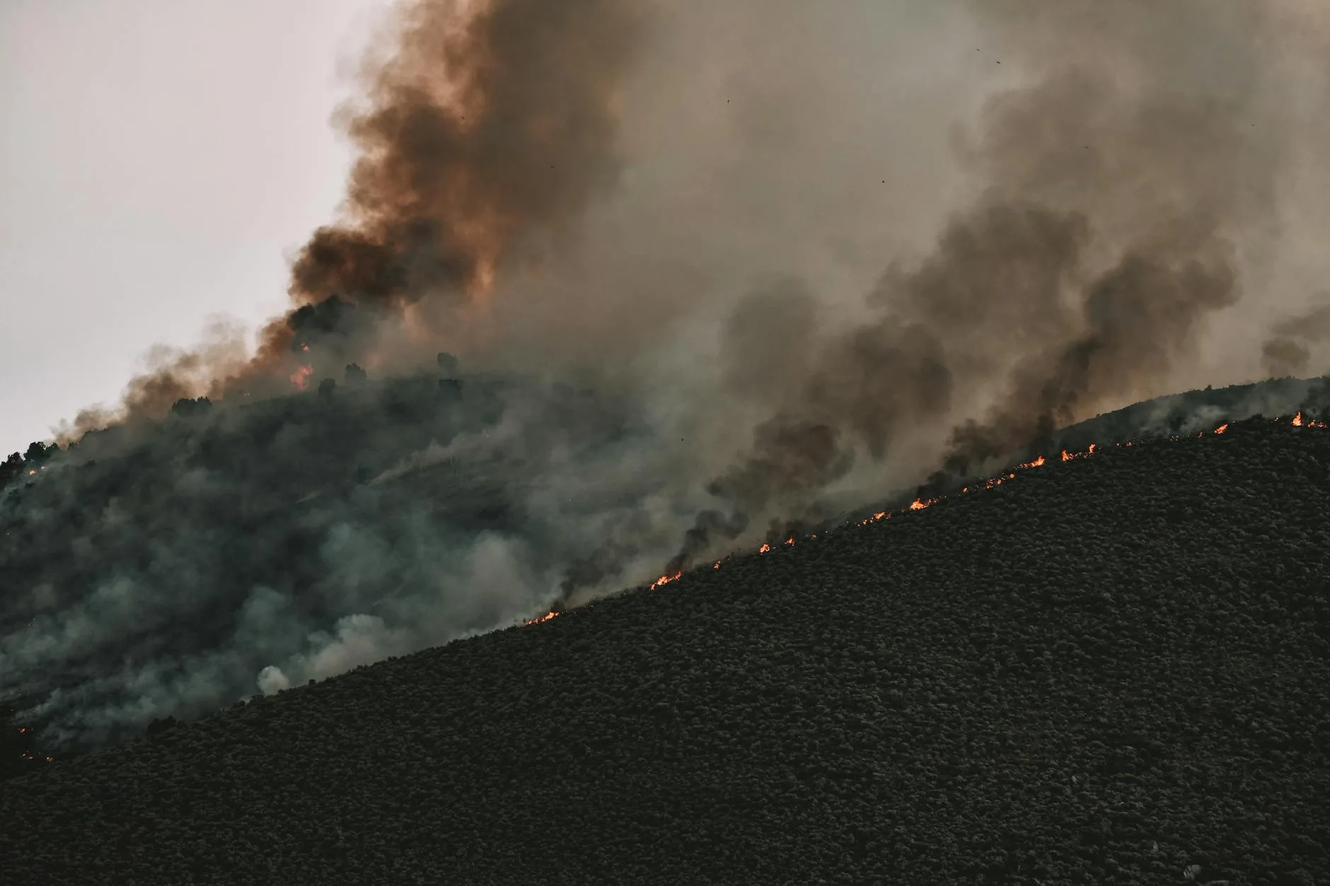
A Fire Weather Watch doesn’t care about your turkey scouting plans. It doesn’t care that you’ve been waiting all winter to walk the Breaks looking for shed mule deer antlers, or that you finally got a long weekend to chase Merriam’s up along the Front. Right now, a Fire Weather Watch is in effect across portions of Montana, and the conditions behind it are the kind that can turn a backcountry ridge into a death trap faster than most people expect. This isn’t a typical late-March situation. Not even close.
What a Fire Weather Watch Actually Means
The National Weather Service issues a Fire Weather Watch when conditions are favorable for extreme fire behavior within the next 24 to 72 hours. We’re talking relative humidity dropping below 15 percent, sustained winds at 20 to 30 mph with gusts well above that, and dry fuels that never got meaningful moisture recovery after a lean snowpack year. It sits one step below a Red Flag Warning. When it upgrades — and it can upgrade fast — things move.
In late March, this is unusual. Most years, residual snowpack keeps the western valleys and the eastern Front country tamped down well into April. But 2026 has been a different story. Grass that cured out hard last fall never got the insulating snowpack it needed, and we’ve already seen wind events that would’ve been remarkable in June. Forecasters and land managers are paying close attention. You should be too.
Which Regions Are Most Affected
The areas of greatest immediate concern are eastern Montana’s grassland and breaks country — Garfield, Petroleum, Fergus, and Chouteau counties — along with the transitional zones running up the Rocky Mountain Front from Choteau south through Augusta and into Cascade County. Southwest Montana, including the Beaverhead and Big Hole drainages, can get vulnerable in a hurry when a high-wind event crashes the humidity.
For turkey hunters, that overlap is significant. Those regions cut right across some of the best early Merriam’s country in the state. For shed hunters working the Missouri Breaks or the BLM ground between the Musselshell and the Yellowstone, that’s your primary operating zone right now. Before you leave the truck, know where you sit on the map relative to current fire risk.
What This Means for Access and Potential Closures
Emergency fire closures can happen fast, and they can shut down public land access with very little warning. The BLM and the U.S. Forest Service both have authority to issue emergency closures when fire danger hits critical thresholds. During an active watch or a Red Flag Warning, rangers can restrict or close recreation areas, roads, and trailheads — sometimes within hours of an ignition.
Check the Montana DNRC Fire Restrictions Map at dnrc.mt.gov before every trip this week — it updates daily during active weather events. Call your local BLM field office or ranger district the morning you plan to go in. The Lewistown BLM Field Office (406-538-1900) covers the Breaks; the Helena-Lewis and Clark National Forest handles much of the Front country. And if a Red Flag Warning gets issued for your area while you’re already out there, get out. Don’t sit around watching the horizon to see how things develop. That’s how people get into trouble.
Practical Safety Steps for This Week’s Trips
Honestly, spring access in Montana doesn’t stop because the fire weather looks rough — but it needs to be adjusted. File a trip plan and tell someone exactly where you’re going, which roads you’re taking, and when you’ll be back. Fire conditions that deteriorate fast can block egress routes without warning, and nobody’s coming to look for you if they don’t know where to start.
Watch the wind. In fire weather, wind is your earliest and most reliable threat indicator. If conditions shift — especially if you catch the smell of smoke — don’t wait around for visual confirmation. Start moving toward your vehicle. Park on gravel or bare ground when you can, too. Catalytic converters on trucks and ATVs can ignite dry roadside grass in minutes during a hot, windy afternoon. It happens every year somewhere in this state.
- Carry a fire extinguisher and a foil emergency shelter if you’re heading into remote country on foot. Lightweight, cheap, and you’ll never regret having them.
- Check spot weather forecasts at weather.gov/tfx or weather.gov/bou — those are the Missoula and Great Falls forecast offices, and they issue location-specific forecasts down to your lat/long for backcountry use.
The Bigger Picture for Spring 2026
This early watch is a preview. Montana’s drought monitor shows significant portions of the state already sitting in D1 to D2 drought conditions heading into spring, and a below-average snowpack year across much of the Rockies means those soil moisture deficits aren’t recovering anytime soon. That’s the kind of deficit that compounds from March all the way through August. In my experience, the years that start like this don’t tend to get more forgiving once summer arrives.
The good news is that spring turkey seasons, shed hunting access, and early bear opportunities are still wide open. Hunt the mornings on calm days. Get out early. Don’t push into exposed ridge country during afternoon wind events — the turkeys, sheds, and bears will still be there when conditions settle. So will you, if you plan accordingly.
Check conditions before you go. Every trip. This week especially.