
BRETT FRENCH | french@billingsgazette.com
Along the West Boulder River in Park County is an 80-acre Bureau of Land Management parcel that has been identified for possible disposal.
Or has it?
The acreage, surrounded by private land, is the only public parcel along the coveted trout stream where other access issues have been brewing over a fence stretched across the stream.
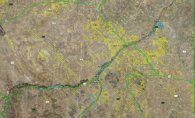
The land is among 6.08 million acres highlighted in an online map identifying Bureau of Land Management parcels scattered across 17 western states that have been identified for possible disposal.
Montana-based onX developed the map in partnership with the Theodore Roosevelt Conservation Partnership to alert the public and policymakers.
“We created this map with TRCP to bring transparency to the land disposal process, to inform outdoor enthusiasts of nearby parcels, and to encourage lawmakers to uphold existing policies that safeguard the public interest when considering any land sales,” said Laura Orvidas, onX CEO, in a statement.
BLM clarifies no sales are occurring
However, a BLM official disputed the accuracy of the map that is based on flexible documents that can change the year after they are written.
“In almost all cases lands with public access would not be disposed of,” said Mark Jacobsen, an information officer with the Eastern Montana/Dakotas district office.
An exception may be when a land exchange would result in the acquired lands providing greater access or more benefit, he added.
Jacobsen also encouraged anyone with questions about specific parcels to contact the appropriate BLM field office for more details.
“We don’t outright sell anything,” Jacobsen said, noting some landowners have gone to BLM offices seeking to purchase acres highlighted on the map or seeking a list of lands being offered for sale, something he said does not exist.
He added that land transfers are a long and complicated process.
Isolated parcels across the West
Nevada had the most acreage identified in the onX map at more than 2.4 million acres, followed by New Mexico with 1.19 million acres and Wyoming at almost 790,500 acres. Montana ranked eighth among the states with 108,045 acres identified – concentrated in the east, along the Hi-Line and in south-central Montana.
“We’re aware that certain plans containing eligible parcels are missing from this dataset,” an onX spokesman wrote in an email. “We will update the map if the data becomes available. And although Alaska contains thousands of acres identified for potential sale, gaps in the available data and the unique legal complexities regarding land sales and transfers in the state kept those parcels off the map.”
Jacobsen said the map isn’t entirely accurate, noting BLM land identified in Miles City contains the agency’s regional office. He also said no one from onX contacted the agency before developing the map.
According to its statement, onX identified the areas using 160 BLM Resource Management Plans. Scattered, isolated parcels are noted in the plans because they can be difficult to access or manage.
“Identification of lands as eligible for disposal does not trigger immediate action, it means those parcels may be considered for sale if and when a proposal is advanced,” the Theodore Roosevelt Conservation Partnership noted in its statement. “Importantly, any future sale must go through a multi-step process that includes additional opportunities for public review and comment. By showing these parcels on a map, the public can more readily participate in any future public process.”
Nervous about public lands
The disclosure comes on the heels of Republican Utah Sen. Mike Lee’s push earlier this year to sell more than a million acres of BLM land to reduce the national debt. Although Lee’s efforts were eventually defeated, the controversy raised an outcry from conservation, recreation and public access proponents concerned about taking the public out of the decision-making process.
The Trump administration has already fast tracked oil, mining and natural gas development on federal lands, including BLM acreage, by eliminating public and environmental review.
“As of January 2025, more than 81% of Bureau of Land Management (BLM) lands in the West — over 200 million acres — are open to oil and gas leasing,” according to research by The Wilderness Society. “Nearly half of the acreage already leased is not producing, much of it held speculatively by industry.”
Montana’s congressional leaders notably opposed Lee’s legislation, which advanced without including any lands in the state before being dropped.
“Public lands, like those managed by the BLM, support 178.5 million outdoor recreation participants who rely on these landscapes to hunt, hike, fish, off-road, ski, climb and bike,” Orvidas said.
The other top five states with BLM acreage identified for possible disposal include California, with more than 715,500 acres, and Arizona at 389,400 acres.
“TRCP is proud to partner with onX to share this valuable tool that shows specific locations of land that could be considered for sale like never before,” said Joel Pedersen, president and CEO of the Theodore Roosevelt Conservation Partnership.
Montana's outdoor week, in your inbox at 7am Friday.